
Your Shopping Cart
blog
The FAA’s UAS Remote Identification Rule and Its Applicability to the UAS Aviation Insurance Industry
Christian Ramsey, Managing Director uAvionix Corporation
Short Answer: The FAA’s Remote ID regulations require U.S. drones to broadcast identification and location data during flight, and that same data is reshaping how UAS insurance companies price policies, investigate claims, and prevent losses.
As the use of Unmanned Aircraft Systems (UAS) continues to increase, the Federal Aviation Administration (FAA) has introduced the UAS Remote Identification (RID) Rule to ensure airspace safety and security.
For the purpose of this article, we will focus on Remote ID requirements, the three ways drones can comply, and how the data is changing the UAS insurance industry.
What Are The Remote Identification of Drones Regulatory Requirements?
Remote ID (formally 14 CFR Part 89) is the FAA’s rule that requires most airborne drones in U.S. airspace to broadcast identification and location information during flight. This rule, which went into effect in September 2023 requires that UAS comply to facilitate their identification and tracking.
Who Has to Comply
The rule covers any drone that weighs between 0.55 and 55 pounds (or 250 grams to 24.9 kilograms). It applies to both recreational and commercial operations, but commercial operators flying under Part 107 must register every drone regardless of weight, so Remote ID applies across the fleet.
Required Broadcast Data
A compliant drone transmits the following information from takeoff to shutdown:
- Drone identification (serial number or session ID)
- Control station location (where the remote drone pilot operates from)
- Drone location (latitude and longitude)
- Drone altitude and velocity
- Time mark
- Emergency status
- Type of ID transmission
The signal goes out over radio frequency and can be received by smartphones, law enforcement tools, and other authorized receivers within range.
How Drones Must Comply with RID
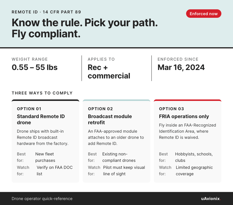
The FAA’s Rule mandates that nearly all UAS operating in the United States comply with one of three ways:
- Fly a Standard Remote ID drone with built-in broadcast capability.
- Attach an FAA-approved Remote Identification Broadcast Module to a non-compliant drone.
- Operate only within an FAA-Recognized Identification Area (FRIA).
Option 1: Standard Remote ID Drones
A Standard Remote ID drone has the broadcast hardware built in at the factory. Most drones manufactured after September 2022 meet this requirement, and many popular commercial platforms from DJI, Skydio, Autel, and Parrot are already compliant.
This option transmits the fullest set of data the rule allows: drone ID, drone location and altitude, drone velocity, control station location and altitude, time mark, and emergency status. Because the drone has real-time information on the pilot’s location, standard RID supports drone operations where the pilot repositions during a flight.
Option 2: Remote ID Broadcast Modules
Broadcast modules are third-party devices that bolt, strap, or plug onto older drones that lack built-in Remote ID. The module handles the broadcast and transmits drone ID, drone location and altitude, drone velocity, time mark, and the take-off location of the aircraft.
The key difference from Standard RID is that these modules broadcast the takeoff point rather than the live control station location. This is why the FAA requires pilots using a broadcast module to keep the drone within visual line of sight at all times.
Option 3: FAA-Recognized Identification Areas (FRIAs)
A FRIA is a defined geographic area where drones can fly without broadcasting Remote ID. Only FAA-recognized Community-Based Organizations (CBOs) and educational institutions can apply to establish one, and the FAA approves CBOs individually. Once approved, a FRIA lasts for 48 months and can be renewed.
For most commercial drone operators, this path has limited practical value. Missions tied to utility inspections, public planning, healthcare logistics, or land surveying rarely fall inside a FRIA boundary. The option matters more for hobbyists flying at a model airfield, schools running UAS programs, and training operations that work within a defined airspace.
Note: Both Standard Remote Identification and broadcast modules must have an accepted Declaration of Conformity (DoC) from the FAA to be used legally, and internet shopping sources reveal a significant amount of hardware on the market that does not have legal DoCs.
Remote ID vs ADS-B
Commercial UAS operators sometimes assume Remote ID and ADS-B do the same thing, but that’s not the case. Remote ID uses short-range Wi-Fi or Bluetooth around 2.4 GHz so smartphones and law enforcement can identify a drone from the ground. ADS-B runs on aviation frequencies (1090 MHz or 978 MHz) at much higher power so crewed aircraft and air traffic control can see and be seen across miles. One is about security and monitoring, and the other is about aviation safety and separation.
Neither technology replaces the other, and the FAA treats them separately. Under 14 CFR §107.53, a drone cannot transmit ADS-B Out unless the operation is under a flight plan with two-way ATC communication or the FAA has authorized it.
For most Part 107 flights within visual line of sight, Remote ID is the only broadcast requirement. Operators moving toward BVLOS, controlled airspace, or flights near crewed traffic need cooperative surveillance on top of it.
One thing Remote ID is not is a Detect and Avoid (DAA) solution. The broadcast moves in one direction, out to receivers on the ground, and crewed aircraft above the drone don’t pick it up. Operators who treat Remote ID as a way to stay clear of other traffic are misreading the rule. The FAA built Remote ID for identification and accountability, inasmuch as security (not airspace safety) is concerned, not for in-flight collision avoidance. Detect and Avoid still requires cooperative surveillance like ADS-B In paired with a wearable alerter or a Ground Control Station feed.
Insurance Companies and FAA’s RID
Remote ID compliance extends beyond FAA enforcement. Remote ID data gives insurers new tools to monitor pilot operating habits, support incident investigation, and offer personalized services.
On-demand UAS insurance apps like SkyWatch provide UAS pilots with a convenient way to obtain insurance coverage tailored to their specific needs. By connecting with the information provided by UAS Remote Identification, these apps can offer valuable insights to tailor coverage to how a pilot flies. Since the technology works with existing mobile device sensors, insurance apps can receive the broadcast directly once the operator registers the drone or module ID during account setup. All that would be required is that the app user register their device ID while setting up the account.
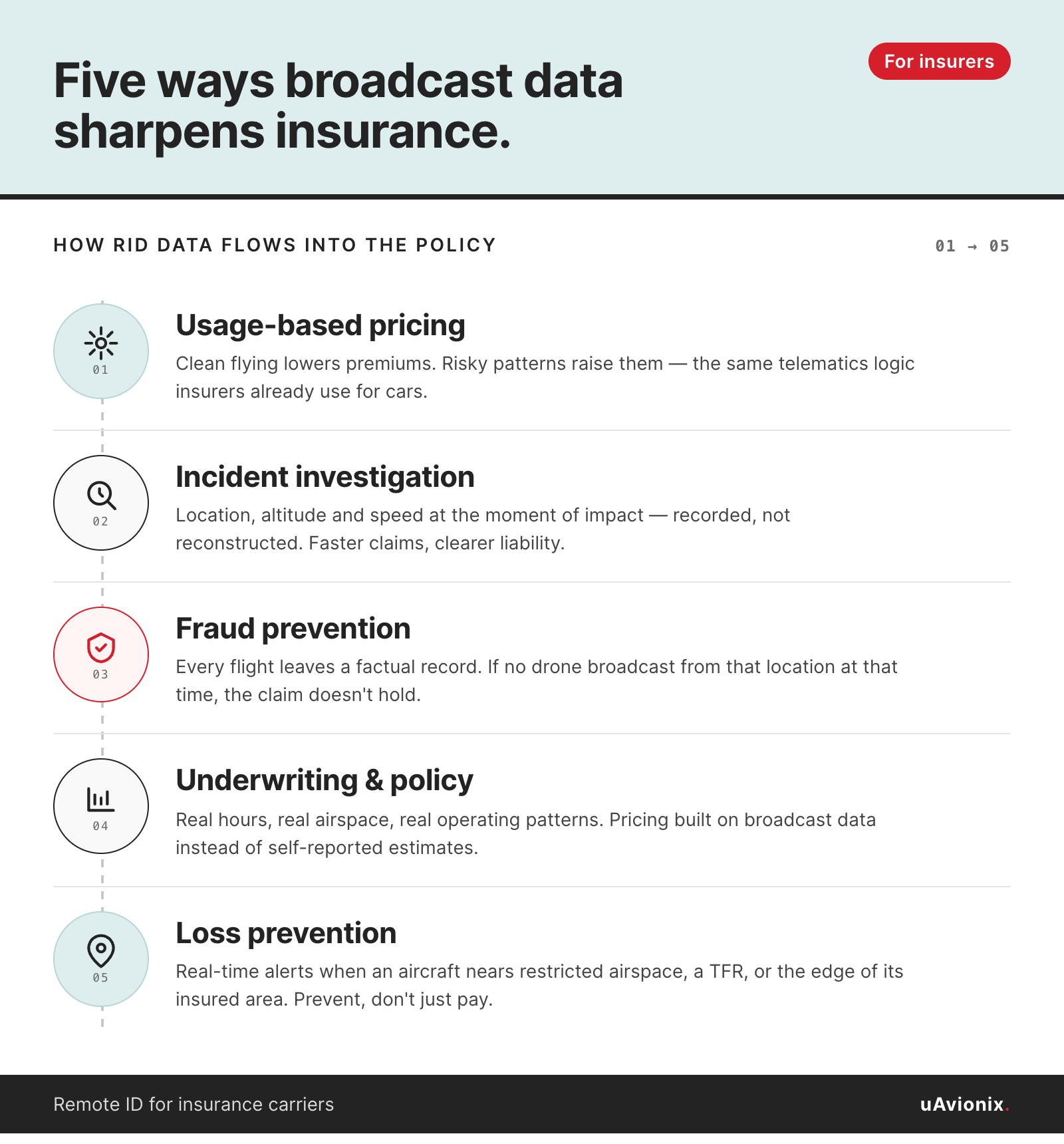
There are several uses for insurance companies that allow for more accurate data and personalized services.
Usage-based Pricing
Much like telematics devices in the automobile insurance industry, which monitor driving behavior to provide personalized insurance rates, UAS RID can help insurance companies assess the risk profile of UAS pilots. By collecting data on UAS pilot operating habits, such as flying in restricted airspace, exceeding altitude limits, flying beyond the insurance coverage boundary, or other patterns of non-compliance, insurance companies can adjust policy premiums to reflect the pilot’s risk level. And operators who fly cleanly can earn lower premiums. Operators who drift into risky behavior will see the opposite. For commercial fleet managers, this matters at scale. A 20-aircraft operation with a clean record may see different pricing than a fleet with inconsistent compliance habits.
Incident Investigation and Claims
RID information can also assist insurance companies in investigating incidents involving UAS. In the event of an accident, the data transmitted by the UAS can provide essential details, such as the aircraft’s location, altitude, and speed at the time of the incident. This information can help insurance companies determine liability, streamline the claims process, and identify potential fraud. For operators, a clean data trail can be the difference between a claim paid quickly and a claim held up for review.
Fraud Prevention
Remote ID broadcasts create a factual record of every flight, which gives insurers a way to validate claims. If a third party reports a drone damaged their property, insurers can check whether any insured aircraft was actually at that location at the stated time. The same logic flags total-loss claims filed on drones that never broadcast that day, along with identity mismatches where the registered operator wasn’t the one flying. For commercial operators, the result is a cleaner claims process. Legitimate claims move through faster, and false claims against a policy have less room to stand.
Underwriting and Policy Issuance
Traditional underwriting relies on operator-reported flight hours and self-described operating patterns, which leaves room for gaps and guesswork. Remote ID changes that. Insurers can pull actual broadcast data to see how many hours a pilot flies, which airspace classes they operate in, and whether their real-world flying matches the policy they purchased. This tightens pricing on both sides. An operator who stays within the declared coverage area gets accurate premiums instead of padded estimates. An insurer who spots flights routinely pushing into uncovered territory can offer expanded coverage rather than deny a claim after the fact.
Loss Prevention
Insurance apps connected to Remote ID can do more than record what happened after a flight. They can warn pilots during it. When an aircraft approaches restricted airspace, a temporary flight restriction, or the edge of its insured operating area, the app can push a real-time alert to the operator. Paired with weather data and active NOTAMs, these alerts turn insurance from a post-event payout into an active safety layer. For commercial fleets, this cuts down on preventable incidents. Fewer incidents mean lower claim volume, and lower claim volume means better pricing at renewal.
uAvionix: Keeping the Skies Safe For All
At uAvionix, we have been involved in aviation safety solutions for UAS since 2015 and have emerged as an industry technology and thought leader. Our work spans certified avionics for crewed and uncrewed aircraft, along with the ground infrastructure that supports UAS integration into the National Airspace System.
For commercial operators scaling beyond visual line of sight, uAvionix builds the cooperative surveillance equipment that makes advanced aircraft operations possible.
The ping200X and ping200X TSO transponders deliver FAA TSO-certified ADS-B Out in a form factor sized for UAS.
The pingRX Pro provides dual-band ADS-B In for Detect and Avoid.
The truFYX GPS supplies the TSO-C145e certified position source that BVLOS waivers and controlled airspace operations depend on.
The pingStation3 is a dual-band ADS-B ground receiver in an IP67-rated enclosure that feeds traffic data to Ground Control Stations, flight information displays, and BVLOS surveillance networks like Vantis and NUAIR.
The skyAlert is a wearable ADS-B receiver that audibly alerts pilots and visual observers when crewed aircraft enter a configurable proximity zone, so operators can stay focused on the drone instead of a screen.
Operators like Wing, Zipline, and Skydio rely on this equipment to fly in airspace shared with crewed traffic.
Remote ID is the starting line for airspace accountability. What comes next is a layered avionics stack that makes commercial UAS operations safe, scalable, and acceptable to regulators worldwide. uAvionix has spent the last decade building the hardware and the standards behind that stack, and we continue to shape how UAS and crewed aviation share the sky.
______________________________________________________________________________________
As of the time of publishing, the uptake on UAS manufacturers implementing Standard RID and approved Broadcast Modules is slow, but climbing. As the FAA and industry ramp up education and communications leading up to the September deadline, the use of RID is expected to rise dramatically. Within a few years, its use will be nearly universal. As the industry matures, operators flying under Remote ID can expect insurers to offer discounts and tailored services based on observed flight profiles rather than speculation.
Updated note (April 2026):
Although universal adoption is not here yet, the FAA reported that over 1.6 million drones were Remote ID compliant as of 2025, and roughly 60% of new drones sold in the U.S. that year shipped with built-in Remote ID. For some older models, manufacturers added Remote ID through a firmware update rather than new hardware. But plenty of older fleets still rely on broadcast module retrofits, and some manufacturers continue to catch up. That gap will close as the current generation of non-compliant drones ages out of service.