Your Shopping Cart
OVERVIEW
The Ultimate ADS-B Ground Receiver
$3,500
SKU: UAX-90083-01
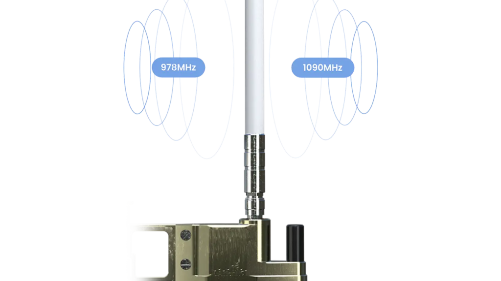
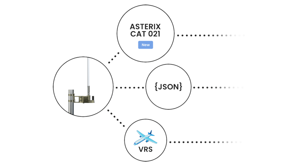
pingStation 3 is a robust, dual-band ADS-B receiver encapsulated in an IP67 weatherproof enclosure for unparalleled airspace and surface monitoring. This networkable device supports both 978MHz UAT and 1090MHz frequencies, offering extensive coverage with a simple Power-Over-Ethernet setup. It seamlessly integrates into traffic management systems worldwide with ASTERIX CAT 021 compatibility, making it ideal for diverse applications from airport monitoring to UAV support.
Primary Features
-
Dual-Band ADS-B Reception
pingStation 3 receives both 978MHz UAT and 1090MHz simultaneously with a single installation, providing comprehensive coverage and surveillance capabilities beyond what single-frequency competitors offer.
-
Enterprise Data Formats
Supports ASTERIX CAT 021 message formats for global compatibility with air traffic management standards, enhancing its utility in professional and commercial settings.
-
Weather Resistant and Easy to Deploy
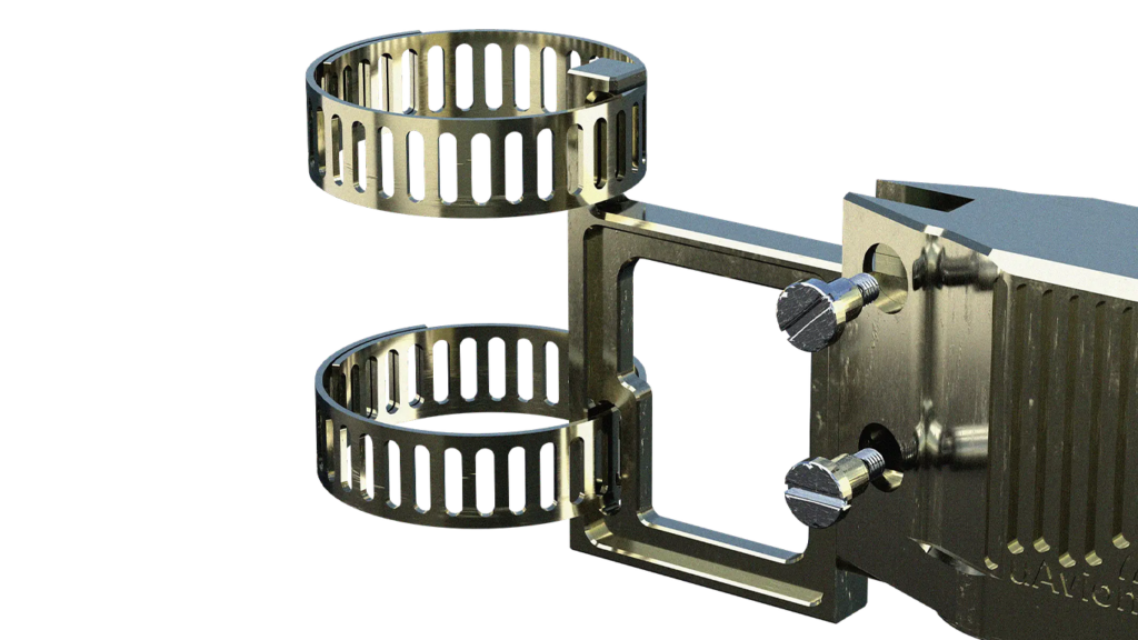
Features an IP67 weatherproof enclosure that houses the receiver, GPS, and antenna, simplifying installation with a quick pole-mount clamp design and a single Power-Over-Ethernet (POE) connection.
-
Versatile Data Output
Offers multiple data output formats including JSON and Compressed VRS, easily integrating into display systems, UAS Ground Control Stations, or Flight Information Displays for versatile applications.
Additional Features
Dual-Band Detection Redefined
Airspace Surveillance Utility
Used in the UK to improve situational awareness at Class G airports by providing a Flight Information Display (FID).
UAS Detect and Avoid (DAA) Technology
Integral to the Vantis UAS Beyond Visual Line of Sight (BVLOS) network and the NUAIR 50-mile UAS Corridor between Syracuse and Rome, NY.
Airport Surface Monitoring
Helps track surface vehicles equipped with VTU-20 at airports, aiding in reducing runway incursion errors.
Easy Configuration and Updates
Configuration is accessible via a web interface with updates manageable through the same portal, ensuring the system is always running the latest software.
Network Capability
Can be networked with multiple units to create a comprehensive low-altitude surveillance system.
Power Over Ethernet (POE) Support
Utilizes POE for power supply, which reduces the complexity of wiring and enhances reliability in harsh environments.
FAQ's
Knowledge Base
- Aircraft Compatibility
- FAA Requirements
- Installation
- Operation
- Maintenance
- Troubleshooting Tips and Tricks
-
-
How does the pingStation 3 detect and manage data from different aircraft types?
pingStation 3 is capable of receiving ADS-B signals from both 978MHz UAT and 1090MHz transponders, which are commonly used by different types of aircraft, including commercial, private, and military. It identifies and processes these signals simultaneously, allowing for comprehensive tracking of varied aircraft types. The system categorizes aircraft based on emitter type, ranging from light aircraft to heavy jets, as well as rotorcraft and unmanned aerial vehicles (UAVs).
-
How does the pingStation 3 detect and manage data from different aircraft types?
-
-
What are the regulatory compliance features of pingStation 3?
pingStation 3 complies with the latest FAA regulations for ADS-B systems, including performance requirements outlined in RTCA DO-260B and DO-282B for ADS-B Out equipment. It supports the ASTERIX CAT 021 message format, ensuring compatibility with air traffic management standards globally.
-
What are the regulatory compliance features of pingStation 3?
-
-
Can you provide detailed steps for installing the pingStation 3?
Installation involves several steps:
- Mount the pingStation 3 using the included bracket and hose clamps on a pole with an unobstructed view of the sky.
- Connect the device to a network using a shielded Cat5e or better Ethernet cable with an M12 connector for Power over Ethernet (PoE) supply.
- Configure the device via its web interface by connecting it to your local network, accessing the device’s DHCP-assigned IP address through a browser, and setting the necessary configurations for data output and network settings.
-
Can you provide detailed steps for installing the pingStation 3?
-
-
How do I access and interpret the data received from pingStation 3?
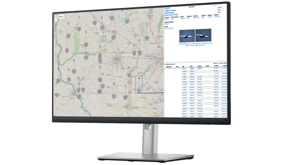
Data from pingStation 3 can be accessed via its IP address on any connected device’s web browser. The data includes detailed information about each tracked aircraft, such as ICAO address, latitude, longitude, altitude, heading, and velocity. Users can configure the output format (JSON, Compressed VRS, ASTERIX CAT021) according to their needs for integration with other systems or applications.
-
How do I access and interpret the data received from pingStation 3?
-
-
What regular maintenance does pingStation 3 require?
pingStation 3 is designed to be low-maintenance, thanks to its robust, weatherproof design. Regular checks should include verifying the physical integrity of the installation, ensuring the Ethernet and power connections are secure, and checking for any firmware updates available to keep the software up to date.
-
What regular maintenance does pingStation 3 require?
-
-
What should I do if I'm not receiving data from the pingStation 3?
If you’re experiencing issues with data reception:
- Check the power and network connections to ensure the device is properly powered and connected to the network.
- Verify the device’s IP address in your network settings and ensure it hasn’t changed or been reassigned.
- Access the device’s web interface to check signal status and system logs for any error messages or alerts.
- Ensure there are no physical obstructions blocking the device’s line of sight to the sky.
- If problems persist, consider resetting the device or contacting uAvionix support for further assistance.
-
What should I do if I'm not receiving data from the pingStation 3?